The North Shore of Sydney is home to many bushland reserves, particularly in steep areas alongside creeks and the harbour, that are home to bushwalking tracks. While you’ll need to skip visiting national parks such as Lane Cove National Park, Garrigal National Park and Ku-ring-gai Chase National Park with your dog, there are plenty of council reserves where dogs are permitted on leash. Check out these options…
Looking for dog-friendly walks all around Sydney? Check out my complete guide to dog-friendly walks and hikes in Sydney

#1 Flat Rock Gully Loop, Northbridge
Distance: 2.3km loop
Difficulty: Medium (Unpaved, uneven ground, can be muddy)
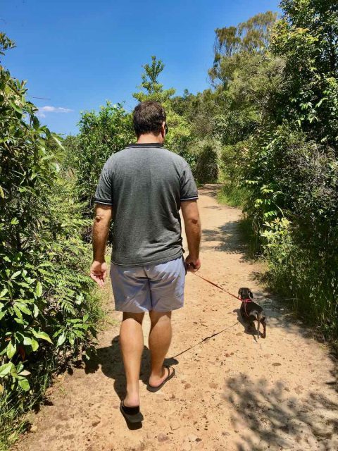
For a fabulous dog-friendly bushwalk on the Lower North Shore, only a 5 minute drive from North Sydney, head to Flat Rock Gully, on the southern edge of Northbridge. It’s hard to believe this gully was once a tip, but it’s now been regenerated and revegetated and is a beautiful spot to walk, without any prohibition on dogs.

There’s a small carpark at the eastern end of Small Street, although the gate locks at night. Alternatively park further back up the street, where the Willoughby Leisure Centre is located.
I followed the directions on AllTrails, with some modifications – I started at the end of Small Street and didn’t loop all the way up to West Street, as I followed a shorter direct route that is better formed and skips walking along the road. You can also download the Willoughby Walks App.
Once you reach the towering Long Gully Bridge at the easternmost point of the walk, consider extending your walk through Tunks Park. There is a paved footpath alongside the edge of the sporting fields, where dogs are allowed off-leash when they’re not in use. After about 750m you’ll reach Long Bay, one of the many quiet bays of Middle Harbour.

Dogs are required to be kept on a leash on this bushwalk, as it’s a Wildlife Protection Area. It’s also advised not to allow dogs enter the creek, with multiple signs mentioning tests for water quality and possible sewerage overflows. Before or after, head to the nearby Incinerator Cafe. It has an excellent outdoor dining area with water bowls for pups.
#2 Harold Reid Foreshore Walk, Middle Cove
Distance: 4-5km loop
Difficulty: Easy-Medium (Mainly dirt track with some steps)
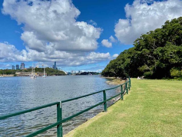
Another great bushland reserve outside of national parks on the North Shore is the Harold Reid Reserve. This reserve is located on a headland protruding into Middle Harbour at Middle Cove, with two creek gullies running along either side.
There are multiple entrance points to the Harold Reid Foreshore Walk: at Sugarloaf Crescent, North Arm Road and the picnic area with BBQs located off Rembrandt Drive in the centre of the reserve. This brochure has an excellent map.

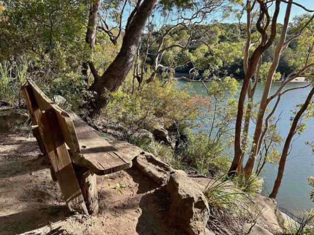
We started the walk at Sugarloaf Crescent, taking the steps through wet forest down to Sugarloaf Creek, with the majority of the path a well-constructed dirt track. A little while after the side track up to Rembrandt Drive the track splits into two.
We took the upper path, as there were steps on the lower path, but the latter probably has better views. In any case, there are some lovely sections of the walk after the two branches again merge, with some short side tracks down to the water.

At North Arm Road, there’s another track that leads back up to Rembrandt Drive, enabling you to return to your starting point at Sugarloaf Crescent or wherever else you started the walk. Note that dogs strictly need to be kept on a leash, as the reserve is a wildlife protection area.
#3 Headland Park Walking Track, Mosman
Distance: 3km return
Difficulty: Easy-medium (Unpaved, some steps)
Further south in Mosman, much of Middle Head lies within Sydney Harbour National Park. However, some parts are contained in the Harbour Trust’s Headland Park, where on leash dogs are allowed, including this great walking track. (The boundaries of the park are marked in blue on the map in the brochure.)
The complete Headland Park Walking Track connects Balmoral Beach in the north with Clifton Gardens Reserve via the Georges Head Lookout. My favourite section of the walk starts at the artists precinct just off Middle Head Road, where free parking is available, and descends down to Clifton Gardens. Part of this walk is called Bungaree’s Walkway.
From the artists precinct (also home to the fabulous dog-friendly Frenchy’s Cafe), head towards the edge of the bushland, where there are a number of gun emplacements and views of the harbour below, then turn right. Along the way you’ll pass a turnoff to Georges Head Lookout, an optional detour, before emerging at Chowder Bay after 1km.
It’s then a short paved walk on to Clifton Gardens Reserve (past another great dog-friendly cafe, Cafe La Mer). At the reserve dogs are allowed off-leash all day long on weekdays, as well as before 9am and after 4pm on Saturdays, Sundays and public holidays. Dogs are also allowed in the water on the eastern half of the beach during the same hours, although not until after 6pm during the summer months.
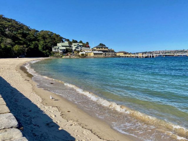
The other half of the walk down to Balmoral Beach involves stairs, so isn’t as dog-friendly, nor is it as picturesque. However, it’s great to combine with a walk along the foreshore at Balmoral Beach. Note though that dogs aren’t allowed on the sand at Balmoral Beach.
#4 Cremorne Point Foreshore Walk, Cremorne Point
Distance: 3km loop
Difficulty: Easy (Paved, but some steps)
One of my other favourite harbourside walks (that isn’t a bushwalk) on the North Shore is located at Cremorne Point, a few kilometres east of the Harbour Bridge. This point is home to a great walking path that follows its foreshore, thanks to a strip of land being kept for public before the grand harbour mansions start.

For this walk, I recommend parking near Bogota Avenue in Kurraba Point, although a free parking spot can be difficult to find on summer days. The walking path starts in between numbers 2 and 4 and heads along the western side of the point. Along the way you’ll pass the Maccullum Seawater Pool as well as plenty of great picnic spots. Continue to the tip of the point and the Robertsons Point Lighthouse.
Return along the eastern side of Cremorne Point, enjoying the National Trust-listed Lex and Ruby Graham Gardens located next to the path, although the gardens are a little run down these days. Then take the steps up to Hodgson Avenue to cut back across to your starting point.

Note that while North Sydney is home to many off-leash dog parks, dogs are required to stay on leash in Cremorne Reserve and along the length of this walking track.
#5 Balls Head Reserve, Waverton
Distance: About 2km loop
Difficulty: Easy-medium (Unpaved)
Less than 2km west of the harbour bridge lies the prominent headland of Balls Head. Unlike Blues Point to the east with its towering apartment building, this headland remains covered in bush, contained in Balls Head Reserve. The reserve is also criss-crossed by a network of paths, punctuated by beautiful vistas across Sydney Harbour to the city.
Park in the small carpark in the centre of the reserve, or further back up along Balls Head Road. Then take your pick from the network of paths to follow, making your way around the headland – it’s about a 2km loop right around the reserve. Note that dogs need to be kept on a leash.
You can also combine this walk with an extension to the Coal Loader precinct, or visit the converted industrial site of Carradah Park on the eastern side of the peninsula. Dogs are allowed off-leash at Carradah Park and the adjacent Waverton Park.
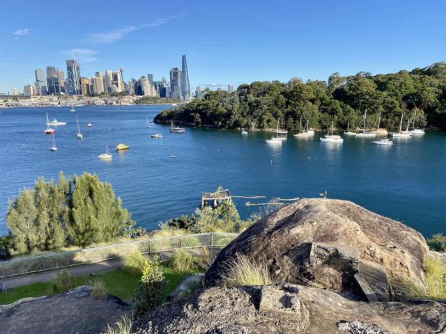
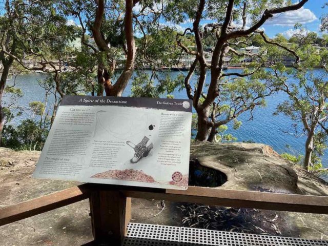
#6 Gadyan Track, Berry Island, Wollstonecraft
Distance: 750m loop
Difficulty: Easy-medium (Unpaved, rocky at times)
A little west of Balls Head is Berry Island, one of the most interesting bushwalks in the North Sydney area, known as the Gadyan Track.
This short 750m-long loop circuits around the former island, which is now joined to the shore by a grassed picnic area, also a popular off-leash dog reserve. Along the way signs detail the life of the former Cammeraygal inhabitants, plus there’s beautiful rock engravings.
Make sure you keep your dog on a leash in the bushland, as in all areas of bush in the North Sydney area. Click here to download the full guide to bushwalk available in the North Sydney council area (just be warned, it’s 15MB).
For a longer walk, there’s tracks through Badangi Reserve on the eastern side of Wollstonecraft, or follow the track to Smoothey Park on the western side of the peninsula (see the brochure linked above for maps).
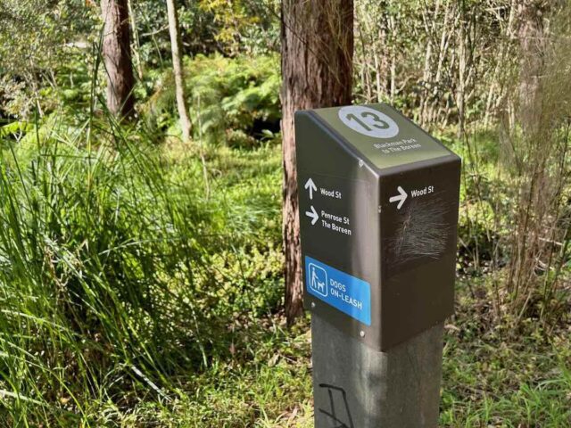
#7 Blackman Park to the Boreen, Lane Cove West
Distance: 2.6km return
Difficulty: Easy-medium (Unpaved, with some steps)
The Lane Cove area is home to multiple pockets of bushland that line its rivers and creeks and also many short bushwalk. One of my favourite dog-friendly walks is the track linking Blackman Park and the Boreen, which runs alongside the eastern side of the Lane Cove River, opposite the Lane Cove National Park.
The main starting point for the walk is at Wood Street, where there is a sign for the start of “Walk 13”, the designation for the walk by the local council. However, it’s easiest to start in Blackman Park, right next to the terrific fenced dog park and Puppy Tail Cafe.
The walk meanders along the bank of the Lane Cove River, ending next to Burns Bay Road, close to a semi-cleaned spot dubbed “The Boreen” where a house once stood. Retrace your footsteps to your starting point.
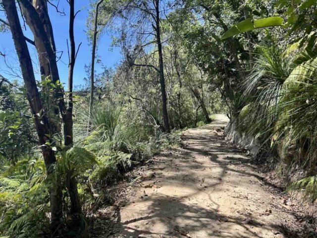
The track is quite rough with many stone steps along the route – it’s best for more agile dogs. There’s a number of branches to different access points that are well signposted, but there’s also a few unsignposted branches to be wary of.
A detailed description and map is in the Bushwalks Around Lane Cove brochure that can be downloaded from the council website.
#8 Two Creeks Track, Roseville Chase
Distance: 6km return
Difficulty: Easy-medium (Unpaved but mainly flat and wide track)
Another great dog-friendly bushwalk on the North Shore is the Two Creeks Track. While dogs can’t hike the full length, as part of the track passes through Garrigal National Park, it’s still possible to walk a reasonable stretch with your dog on a leash.
The best spot to start with your dog is at the end of Babbage Road in Roseville Chase. where there’s a prominent sign. The initial section starting from the sign is rather rough, until it meets a wider track just before it heads under Roseville Bridge. You could also take the wider track, which starts from the driveway just before the end of the road.
The rest of the track is fairly wide and flat, with plenty of evidence of recent upgrades, that still weren’t quite complete when I hiked it in late 2025. (Perhaps the start of the track will also be upgraded?) It mainly follows the mangrove-lined Middle Harbour with a loop around Moores Creek.
The wooden bridge across Moores Creek is about 1.3km from the Roseville Bridge. At this point there is a junction with the Little Digger Track, that leads up to Carnarvon Road in East Lindfield. From this point it’s another 1.5km to the edge of the national park.
I couldn’t see any signs for the national park, but instead there’s a sign about 1080 baiting – watch out for it. It’s only a few hundred metres after the side path to Wellington Road (a steep track with lots of steps that I don’t recommend). There’s a nice spot nearby where you can access the rocks along the edge of the harbour.
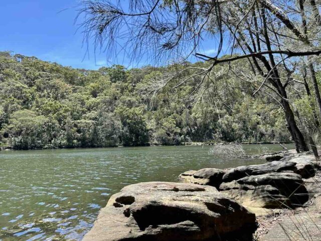
Close to the start of the track at Babbage Road is Echo Point Park. If you head past the picnic area there’s the sandy Roseville Marina Beach. While it’s an on-leash area, it was popular with locals and their dogs on the day I visited.
A Note on 1080 Baits
Many of these bushland reserves make use of 1080 baits to control foxes that may sometimes be found on the North Shore. Generally baiting occurs at most reserves once a year, with signs warning of upcoming baiting and when baiting takes place. Take note of any signs and skip entering the reserves with your dog during baiting periods. The national parks in the area often make use of baits year-round.
You May Also Like
- More dog-friendly walks & hikes in Sydney
- Top Dog-Friendly Walks on the Northern Beaches of Sydney
- Top Dog-Friendly Walks on the Central Coast of NSW
About the Author

Shandos Cleaver is the founder of Travelnuity: Dog-Friendly Travel. She has travelled extensively with her Miniature Dachshund, Schnitzel, including to 33 countries across Europe, every state and territory of Australia except Tasmania, and 10 of the United States. She’s passionate about providing inspiration and information to others wanting to travel with their dogs, whether close to home or internationally.